File:Konfessionen Deutschland Zensus 2011.png
Jump to navigation
Jump to search


Size of this preview: 419 × 599 pixels. Other resolutions: 168 × 240 pixels | 336 × 480 pixels | 420 × 600 pixels | 537 × 768 pixels | 717 × 1,024 pixels | 2,480 × 3,543 pixels.
Original file (2,480 × 3,543 pixels, file size: 1.91 MB, MIME type: image/png)
Captions
Add a one-line explanation of what this file represents
Captions
Summary[edit]
| Description |
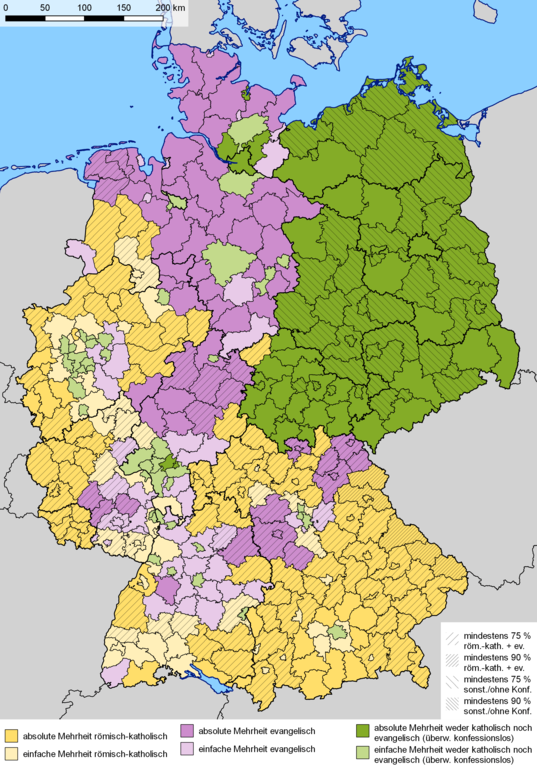
Deutsch: Dominierende Religionszugehörigkeit auf Landkreisebene nach Ergebnissen des Zensus 2011 in Deutschland. Violett: evangelisch, gelb: katholisch, grün: andere (konfessionslos, sonstige Religionen oder keine Angabe). Dunkel: absolute Mehrheit (> 50 %), hell: relative Mehrheit English: Dominant religious affiliation at district level according to the 2011 census in Germany. Mauve: Protestant, yellow: Catholic, green: other (no denomination, other religion or not given). Dark: absolute majority (> 50 %), light: relative majority
|
| Date | |
| Source |
|
| Author |
|
| Permission (Reusing this file) |
The files provided by the Statistische Ämter des Bundes und der Länder are open data, freely usable even for commercial purposes with no special permission needed, according to German law, see GeoNutzV (Verordnung zur Festlegung der Nutzungsbestimmungen für die Bereitstellung von Geodaten des Bundes) |
Licensing[edit]
I, the copyright holder of this work, hereby publish it under the following licenses:

|
Permission is granted to copy, distribute and/or modify this document under the terms of the GNU Free Documentation License, Version 1.2 or any later version published by the Free Software Foundation; with no Invariant Sections, no Front-Cover Texts, and no Back-Cover Texts. A copy of the license is included in the section entitled GNU Free Documentation License. |
|
This file is licensed under the Creative Commons Attribution-Share Alike 3.0 Unported, 2.5 Generic, 2.0 Generic and 1.0 Generic license. | |
|
You may select the license of your choice.
File history
Click on a date/time to view the file as it appeared at that time.
| Date/Time | Thumbnail | Dimensions | User | Comment | |
|---|---|---|---|---|---|
| current | 07:19, 7 January 2019 | | 2,480 × 3,543 (1.91 MB) | Gretarsson (talk | contribs) | QGIS generated map with update of administrative borders (mainly Landkreise of Mecklenburg-Vorpommern), based on same data source as original version (Census 2011); colour of Landkreise with majority of people without religious belief and/or minority religions changed to greenish |
| 11:50, 20 March 2015 |  | 2,000 × 2,655 (937 KB) | RokerHRO (talk | contribs) | optipng -o7 -i0 → 41.10% decrease | |
| 09:34, 24 June 2013 |  | 2,000 × 2,655 (1.55 MB) | Michael Sander (talk | contribs) | {{Information |Description=Dominierende Religionszugehörigkeit auf Landkreisebene nach Ergebnissen des Zensus 2011 in Deutschland. Lila: evangelisch, gelb: katholisch, blau: konfessionslos (und sonstige Religionen oder keine Angabe). Dunkel: absolute ... |
You cannot overwrite this file.
File usage on Commons
The following 3 pages use this file:
File usage on other wikis
The following other wikis use this file:
- Usage on ar.wikipedia.org
- Usage on bg.wikipedia.org
- Usage on de.wikipedia.org
- Usage on en.wikipedia.org
- Usage on es.wikipedia.org
- Usage on fa.wikipedia.org
- Usage on fr.wikipedia.org
- Usage on hr.wikipedia.org
- Usage on id.wikipedia.org
- Usage on it.wikipedia.org
- Usage on la.wikipedia.org
- Usage on pl.wikipedia.org
- Usage on ru.wikipedia.org
- Usage on zh.wikipedia.org